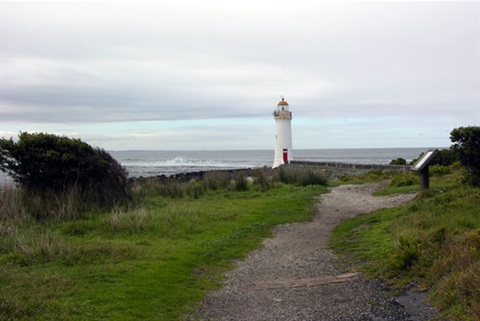
Griffiths Island - Port Fairy
Griffiths Island is a sanctuary for plants, birds and animals.
The island is about 1.5 kilometres long and 0.8 kilometres wide at its widest point. It is bordered on its northern side by the Moyne River, which has been channeled between stone 'training walls' and provides easy access by sea to the port of Port Fairy. Originally a cluster of three separate islands – Goat, Rabbit and Griffiths – harbour works have consolidated them into a single island which protects the mouth of the Moyne and shelters Port Fairy Bay.
It is named after John Griffiths, an entrepreneur and merchant from Launceston in northern Tasmania.
From the mid 1830s until 1843 the island served as a base for a bay whaling station for Southern Right Whales, until the supply of whales was exhausted and the industry went into terminal decline. Some shipbuilding also took place during the 1840s. The abandoned whaling station buildings were later used until 1854 by Flora Dunlop, widow of Victorian politician Alexander Dunlop, as a ‘mission’ for young Aborigines. Because of its historic and archaeological significance, the island has been listed on the Victorian Heritage Register.
There is a large breeding colony of short-tailed shearwaters, locally known as ‘muttonbirds’, with an estimated 100,000 burrows (of which probably fewer than half are occupied during the September–April breeding season).
Griffiths Island has been reserved as public land since 30 April 1902 with Moyne Shire Council (formerly the Borough of Port Fairy) the Committee of Management since 11 June 1902
The official title of Griffiths Island – is “Griffiths & Rabbit Islands Public Park”.
Information guides